Category: Clever Scientific Monitoring
PROJECT OVERVIEW
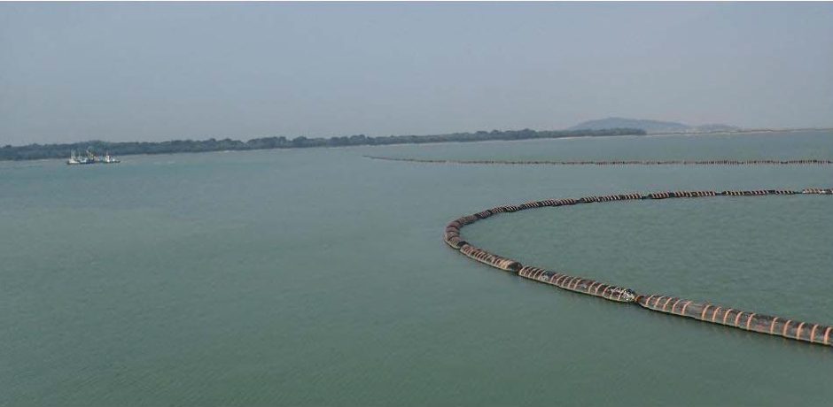
Singapore has one of the busiest sea ports in the world. Located at the crossroads of many m ajor shipping routes, Singapore is a focal point of some 400 shipping lines with links to more than 700 ports around the world. Given much of its territorial waters are dedicated to marine use, there are limits to how much land Singapore can reclaim.
Two new reclamation projects were recently launched at Pulau Tekong and Tuas View Extension. As these large scale projects were being carried out, Malaysia alleged that the works were having an adverse impact on their territorial waters. Singapore’s ongoing reclamation works were subject to consideration by the International Tribunal for the Law of the Sea on the grounds that they were causing trans boundary environmental harm. In the resolution paper it was determined that the works were not having the adverse impacts as claimed, but that strict monitoring needed to be undertaken to ensure this remained the case.
The use of 3D hydrodynamic and sediment plume modelling is considered international best practice and was used as the benchmark for all WorleyParsons modelling. Three dimensional hydrodynamic numerical modelling of sediment plumes underpins the scientific assessment of potential impact from dredging and sediment disposalactivities. WorleyParsons developed a front and backend system, called Neptune, to pro-actively manage any marine construction activities using sophisticated hydrodynamic models. This groundbreaking initiative to monitor all of Singapore’s territorial waters in 3D every hour in near-real-time is a global first and utilises a cutting-edge algorithm. Harnessing the power of satellite technology and cloud computing, WorleyParsons can identify where construction-related plumes or altered currents are affecting environmental receptors including in this case, at the Singapore/Malaysian boundary. The Neptune facility means that data that would previously have taken years to process can now be viewed and analysed in a matter of seconds and government officials can now see where plumes are crossing the border (in 3D in near-real-time), or can even receive automatic alerts when this occurs to enable impacting activities to be stopped before more damage is done.
SIGNIFICANT ASPECTS
While Singapore has utilised 2D modelling and huge field-based monitoring programs for the past 10 years, WorleyParsons recognised there was an opportunity for improvement and that they needed to be technically innovative in order to break into the market and deliver.
From its Centre of Excellence for Marine Sciences based in Perth, the firm created a solution that required development of complex hydrodynamic models, procedures for updating the spill budget and a quality control algorithm that rejected data sent by third parties if it did not meeton live telemetry information infield. The boundary issues also mean that there was extreme sensitivity around the project works.
As Singapore’s ongoing reclamation works were summoned to the International Tribunal for the Law of the Sea, WorleyParsons developed modelling solutions to proactively enable construction to continue, ensuring real time results and efficient monitoring.
The solutions included:
• Daily model hindcast
• Daily forecast analysis
• Daily satellite imaqery analysis
• Acoustic ADCPs
• Reports on the tonnage spilt daily, setting the nex t 48 hours’ spill budget.
All this was undertaken automatically through WorleyParsons’ Neptune platform- coupling together a complicated modelling, cloud computing and validation program-and using the technology in innovative ways. WorleyParsons was able to deliver daily reports within 24 hours to proactively manage the results from the dredge-related impacts while helping to save approximately 50 per cent in costs compared to other tender prices. This ambitious and innovative monitoring program helps overcome the ocean information challenge and gives users the power to protect environmentalquality objectives before adverse impacts can occur. Neptune allows governments to respond quickly to incidents, marine contractors to have more control over their construction process,and academics, NGOs, the media and the pulblic due to the wealth of information.
Our most recent client is a government body in Australia where we have flown Endeavour for more than 100 days delivering various missions, using a multitude of sensors including infrared, multi-spectral, HD photogrammetry and video, often live-streaming data and images to our client.
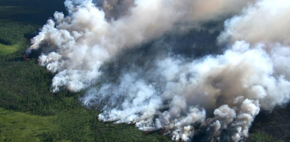
Client Challenge
During the summer months in Australia, country residents are constantly vigilant and in a state of preparedness to deal with the impacts of the bushfire season. Similar devastating effects were seen in a wildfire in the Canadian province of Alberta. The difficulties that local fire authorities are having in bringing the blaze under control.
The response from governments worldwide is to continually find new and smarter ways of managing the impacts and consequences that arise from bushfires.
Their challenge is to develop better ways of identifying, monitoring and planning their response to such disasters.
Our Solution
In this assignment, our team assisted our client to gather data to monitor bushfires more effectively. This helped them to establish appropriate mechanisms to save lives and properties during the occurrence of bushfires.
This assignment was achieved through a combination of aerial data acquisition using an Unmanned Aerial Vehicle (UAV), and the use of Digital Enterprise’s data processing and integration platform called Assure.
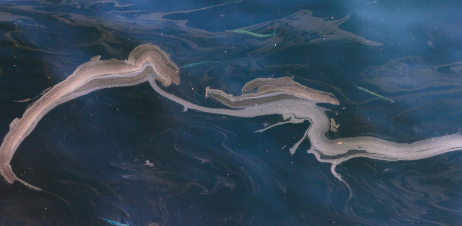
The Deepwater Horizon oil spill presented an unprecedented threat to the Gulf of Mexico marine resources. It is the largest accidental marine oil spill in history, with almost 5 million barrels spilled. Although the amount of oil gushing to the surface diminished after the well was capped, scientists did not stop gathering data, or looking for ways to avoid future disasters.
Both during and after the oil spill, researchers captured information about the way oil breaks down, dissipates, and bioaccumulates. Their goal: to improve the technology used to mitigate the impact of such disasters.
Oil drifts along the surface of ocean water at 97% of current speed, but only a fraction of the wind speed. Therefore, it is essential to track the water currents, since they account for at least 95-98% of the ultimate oil spill trajectory.
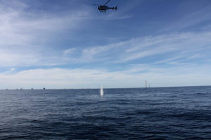
Advisian designed, developed and now deploy Oil Spill Tracking Buoys (OSTBs) to accurately track a surface oil spill, with movement of the buoy limited to the metocean conditions found at the immediate air/sea interface and in the upper 0.5 m of the water column. For fast response, it can be deployed from a helicopter for oil spill response monitoring using satellite tracking modems. The buoy has close to zero windage, yet still sends and receives satellite GPS fixing data.
The main priority in the event of a spill is to accurately track its extent and trajectory to facilitate a rapid clean up. Deploying the OSTB ensures that impact assessment activities and oiled wildlife operations are focused on the correct areas, helping to reduce the overall environmental impact of a spill. Each buoy has its own identification number and can be tracked 24 hours a day, seven days a week. This system allows determination of the exact position of oil, icebergs, and search and rescue teams, to track them in real-time and at any point on the planet.
Every hour saved by not deploying teams to the wrong area to clean the spill is a high risk or impact hour saved. During the Deep Water Response effort, the Macondo Oil Field had 1500 vessels, 830 skimmers and 3.47 million feet of boom. 50% of this clean-up effort was in the wrong area due to the tracking buoys not tracking the oil appropriately. As such, if each vessel had 5 crew on board for a standard working day, then approximately 5750 high-risk man hours could have been eliminated each day if they were directed to the correct place.
Previous project experience, examination of existing oil spill response systems and model validation exercises have shown that multiple OSTBs need to be deployed across a variety of locations during an oil spill incident, namely spill fronts and spill central points. This is vitally important for any Oil Spill Response Team for planning its incident response effectively, and to enable the emergency numerical modelling systems that predict the fate of a spill.
Subsea mining as a commercial venture has been around since the 1960s, however it has been slow to gain traction. The greatest barrier to its widespread adoption is environmental in nature. The question many countries are asking, including New Zealand, is ‘Can subsea mining be sanctioned whilst maintaining a focus on environmental sustainability?’
Subsea mining involves the extraction of mineral resources from the seabed, with a diverse range of resources available, from aggregates through to high value mineral deposits. The latter resources include Seafloor Massive Sulphides (SMS), poly-metallic or manganese nodules, rare earths, copper and even diamonds. Deposits are generally found around hydrothermal vents (typically between 1,400 – 3,700 m below the ocean’s surface) which form above cracks in the ocean floor. These cracks usually occur in volcanic areas, meaning countries located on or around areas of tectonic instability, such as New Zealand, Fiji, Tonga, or Papua New Guinea, are rich in these deposits.
The attempts at subsea mining were first recorded back in the 11th century BC, when the Phoenicians mined beds of seashells to extract a material they used to make purple dye. Probably the first recorded mineral extractions occurred in the third century BC when divers mined copper ore (from a depth of 4 m) near the island now known as Heybeli in the Bosporus. It wasn’t until the 1960s and 70s however, when a number of consortia began mapping hydrothermal vents and the resources they contained, that the true potential for subsea mining began to be realised.1
Why would we want to mine under the sea?
Like all mining activities, there are four key criteria that need to be met:
- Is it technically feasible?
- Is there a good economic case for it?
- Does it comply with all applicable regulations and law?
- Will the public find it environmentally acceptable?
Before even considering these questions, some may ask ‘Why attempt such risky endeavours in the deep, when there are deposits to be found on land?’ The answer is two-fold; quantity and quality.
There are numerous onshore mineral deposits found around the world, with approximately 30% of the earth’s total surface area being land, and the remainder water. Though not exact, the ratio for mineral deposits would be similar, with 30% onshore and 70% offshore. This means there is likely a great quantity of mineral reserves yet to be found subsea. The other factor is the quality of the deposit. In many mining operations on land we can see only 12% of resources recovered.2 In contrast to this is the quality of subsea minerals, with their composition being such that they are nearly 100% recoverable from the extracted ore body.3 This is why on quantity and quality criteria, subsea mining can provide a compelling case.
Where is it happening?
There have been a number of attempts around the world at subsea mining, with varying degrees of success. De Beers has been mining economic amounts of diamonds from subsea deposits since the 80s. Currently the best potential deep sea site, the Solwara 1 Project, found in the waters off Papua New Guinea, is a high-grade copper-gold resource, and the world’s first SMS resource. This development proposes sea floor mining at depths of up 2000m. At the depths envisaged conventional sea floor mining techniques such as suction dredges must be replaced by specialised sea floor mining tools such as autonomous underwater vehicles (AUV’s) which can operate independently of the surface production support vessel (PSV) or remotely operated vehicles (ROV’s) .
One country that potentially could benefit from subsea mineral deposits is New Zealand. Though a small country, it has an economic exclusion zone of some 4m km2, twice as large as China’s, and due to the geology and formation of the country it is rich in seabed minerals. With huge reserves available it is understandable why it could be an attractive proposition. For example, an investigation undertaken in 2012 for NZ Petroleum and Minerals (the Government agency responsible for mineral exploitation) on the potential for New Zealand Seafloor Mining in the Kermadec Arc region established that there was a strong case for further exploration and investigation of these territories (Transfield Worley New Zealand, 2012). Whilst some of this potential will be enclosed within the ocean sanctuary area recently announced by Government intended to protect the marine habitat, significant areas remain outside the sanctuary.
However in order for New Zealand to make use of these minerals they would need confidence that potential environmental impacts from the project could be properly mitigated.
Technical and economic feasibility
Given the right resources, both human and economic, anything is technically feasible . In the area of subsea mining, many industries have been doing it for quite some time.4 Each project will have its own challenges, whether it is extraction or processing, but it’s safe to say that there are no real technical reasons why commercial-scale operations aren’t possible.
From an economic perspective, most mines only become profitable once they’ve been in full production for a number of years. The same inputs into the business case for a mine onshore will be the same for one subsea. Even though there will be technical and financial challenges, the greatest hurdle to overcome is environmental, which will necessarily impact the business case with the management of environmental effects requiring specific attention. Regulatory oversight will be an important component of any risk mitigation strategy. Delineation and resolution of such issues and challenges is a major consideration in the front end development of any commercial investment of scale.
What are the environmental concerns?
Under NZ law, the disturbance or removal of material from the seabed and the deposit of tailings to the sea floor as a result of the mining activity are restricted activities and require a marine consent from the Environmental Protection Authority (EPA). Mining companies are required to submit detailed impact assessments as part of the marine consent process. This includes identifying any effects of undertaking the proposed activities on the environment or existing interests or other activities undertaken in the area. Measures taken to avoid, remedy or mitigate any adverse effects must be taken into consideration. One of the biggest issues around subsea mining is the plumes that mining activity will create and the extent of disturbances and impact on the local seabed ecology Including seabed habitats, marine mammals and fish stocks.
New Zealand has had two proposals (an iron sands project and a phosphate project) rejected in the past twelve months, with some groups calling for moratoriums on subsea mining. This was due in part to the outcomes of the Environmental Impact Assessment (EIA) submitted by the companies which set out to predict the size and extent of the impact on the environment or existing interests. Rightly these models looked at a worst case scenario, being a year of full production with continually turbulent sea conditions, but given the variabilities inherent in these two factors the outcomes did not provide the certainty (as is the nature of all models) that people needed to see around likely environmental effects.
The question that thus arises is whether it is then possible to conduct mining activities in a manner that will never see this worst case scenario occur and thus reduce the likelihood of environmental harm? The short answer is yes.
There are many case studies globally of how proactive adaptive monitoring provides an acceptable solution to the management of environmental impacts; be it dredging near sensitive coral reefs in the Pilbara, marine construction next to sensitive industrial pipe intakes, or reclaiming close to countries borders, Advisian has been involved with them all.
Advisian’s solution
The key to arriving at an acceptable solution is to understand these receptors and cut-off limits and then model backwards to work out acceptable limits (xm3 of spoil) that won’t come close to breaching the limits. This is possible in New Zealand. A similar matrix to a dive table can be produced combining the months of the year (to account for seasonality), with relevant metocean conditions (like a Beaufort scale). Teams can then analyse how much can be mined every day without breaching any receptors. Tonnages can be increased or decreased accordingly to daily metocean conditions, thus managing the potential for plumes, and thus environmental harm.
Controlling the mining operation in this manner is a relatively simple task, with matrix results used as inputs into the economic model to ensure viability, and also as part of operational contractual terms to ensure compliance. Advisian is currently doing exactly this for current reclamation in Singapore and elsewhere in the world. The hard part is gaining widespread acceptance that the approach is valid and relevant to New Zealand.

Next Steps
With the quantity and quality of resources available, subsea mining will eventually become more common. Countries along the Pacific Rim, or indeed anywhere with good volcanic activity in adjacent oceans, stand to reap the rewards when operations commence. For New Zealand in particular, this will mean adopting a different approach to examining the potential effects on the environment form plumes and mining discharges. We suggest a preferred approach is to give a greater cognizance to understanding the desired limits for where environmental receptors are breached, rather than seeking to gain a perfect understanding through the simple modelling of effects.
References
- http://www.asienhaus.de/archiv/asienhaus/tiefseebergbau2009-2014/Seib-Compilation_deep-sea_mining_2009-2014.pdf (page 260)
- Thanatia, the destiny of the Earth’s mineral resources: a thermodynamic cradle to cradle assessment, A. Valero Capilla, 2014, World Scientific Publishing Company (page 628)
- http://www.ut-2.com/Issues/Issue6.pdf (page 39)
- https://www.isa.org.jm/sites/default/files/files/documents/2000-othermins.pdf